Volcano Live
volcanolive.com
Karkar Volcano | Dr John Seach
Last updated: January 2026

Madang Province, Papua New Guinea
4.65 S, 145.96 E
summit elevation 1839 m
Stratovolcano (island)
Karkar Island is located 64 km north of Madang. The island is 25 km long and 19 km wide with two summit calderas. The main caldera is almost perfectly circular 3.2 km in diameter with vertical walls 300 m high. Karkar is an andesitic stratovolcano, which is part of a chain of 15 volcanic islands in the western part of the Bismarck volcanic arc.
Warning: Sudden explosive eruptions, ash plumes, and pyroclastic flows possible. Island location increases evacuation challenges. Exclusion zones enforced during unrest; access to crater hazardous.
Geology and Volcanology
Karkar is an andesitic stratovolcano on an island with a large circular caldera. Activity centers at Bagiai cone on the caldera floor. Part of the Bismarck volcanic arc. Eruptions are Strombolian to phreatic with occasional lava flows. Monitored by Rabaul Volcano Observatory with seismicity and visual data.
Current Activity (January 2026)
Karkar remains at low unrest. Minor fumarolic emissions from Bagiai cone. Low seismicity. No eruptive activity. Monitoring by RVO ongoing.
Karkar volcano photos by Dr John Seach
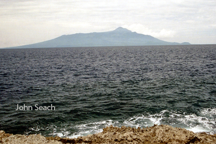
Karkar volcano, Papua New Guinea
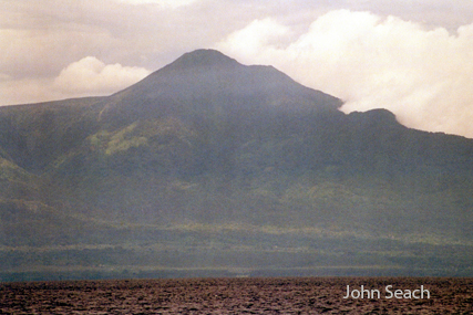
Karkar Island
Post-2013 Quiescence (ongoing)
Low-level fumarolic activity.
2013 Eruptions
A volcanic ash plume to 14,000 ft altitude drifting 20 nautical miles NE was reported on 29 January 2013. A high level eruption occurred at Karkar volcano, Papua New Guinea on 26th February 2013. Ash reached 30,000 ft altitude. Ash reached 28,000 ft altitude and drifted 40 nautical miles north on 16th March 2013. Aviation code was raised to RED.
2012 Activity
Possible ash emissions were observed by satellite at Karkar volcano on 1st February 2012.
2009 Unrest
Alert level increased to 3 (Siaga) at Karkar volcano on 17th August 2009. This follows a series of tectonic earthquakes in Mentawai, 130 km SSW on 16th August, and an increase in tremor at the volcano. A magnitude 7.6 earthquake hit 80 km NW of the volcano on 30th September 2009.
2008 Tornillo Earthquakes
Tornillo earthquakes commenced at the volcano in February 2008, and were catalogued during a visit by Dr John Seach. During a summit climb in March 2008 John Seach noted summit earthquakes, high pressure noisy fumaroles, and devastated forest from the 2005 eruption.
2007 Ash Emissions
During 18-25th June 2007, thick brown ash plumes rose to an altitude of 3.1 km.
2005 Eruption
Talang volcano erupted on 10th April 2005, 12 days after the second Sumatra earthquake (Magnitude 8.7).
Saturday 16th April 2005.
Over 40,000 people have been evacuated from the slopes of Talang volcano in Sumatra. A five kilometer exclusion zone has been declared around the craters. There is potential for significant eruption. Aircraft should exercise caution when overflying the area. Talang volcano remains at the highest level of alert at 4.
Monday 18th April 2005
The alert level at Talang volcano in Sumatra has been reduced from 4 to 3. The volcano erupted on Tuesday 12th April. Volcanic activity has declined over the past few days.
Saturday 16th April 2005.
The eruption of Talang volcano during the week has caused the evacuation of thousands of refugees, who have spent a third night in tents. The eruption has also affected tea plantations close to the volcano, which have been covered in ash. The evacuated villages are: Bukit Cileh (3,485 people), Batu Bajanjang (3,632), Koto Laweh (4,660), Kampung Batu Dalam (8,112), and Air Batumbua (2,815), a total of 22,713 people. In addition 5,000 residents from nearby villages voluntarily left their homes.
News report by John Seach, 12th April 2005.
Talang volcano erupted on 12th April 2005, with ash to 25,000 ft. Talang volcano is located in Sumatra, close to recent large earthquakes. Talang is on a list of volcanoes identified at risk of eruption by John Seach following the large earthquakes in the region. (See Volcano Live news reports for 10th April 2005, and 30th December 2004). The volcano is at maximum alert level 4 (out of 4) and volcanic activity has been increasing following Mentawai earthquake of 10th April. Talang volcano is just 40 kilometers east of the coastal capital of West Sumatra province, Padang.
Further reading
Poedjoprajitno, S., 2012. Morphostructure Control Towards the Development of Mahawu Volcanic Complex, North Sulawesi. Indonesian Journal on Geoscience, 7(1), pp.39-54.
Siahaan, E.E. et al., 2005. Tectonism and volcanism study in the Minahasa compartment of the north arm of Sulawesi related to Lahendong geothermal field, Indonesia. Proceedings World Geothermal Congress.
Karkar Volcano Eruptions
2013, 2012?, 2009, 2008, 2007, 1979, 1974-1975, 1974, 1962?, 1895, 1885, 1830?, 1643