Volcano Live
volcanolive.com
Pacaya Volcano | John Seach

Guatemala
14.38 N, 90.60 W
summit elevation 2552 m
complex volcano
Pacaya is one of the world's most active volcanoes. It lies approximately 25 km south of Guatemala City. Activity at the volcano consists of strombolian eruptions, ash eruptions, and lava flows.
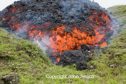
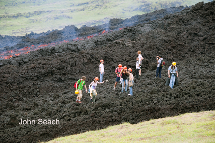
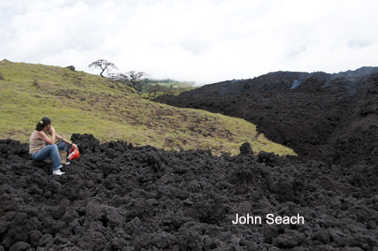
Pacaya volcano photos by John Seach
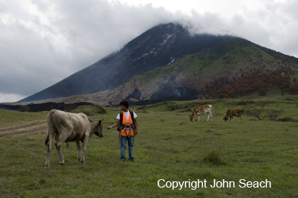
Pacaya volcano 2010
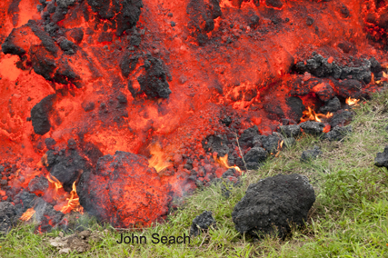
Pacaya volcano lava flow 2010
Pacaya volcano lava flow 2010
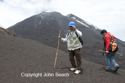
Summit cone of Pacaya volcano (MacKenny cone)
Pacaya eruption 2010
Pacaya lava flow 2010
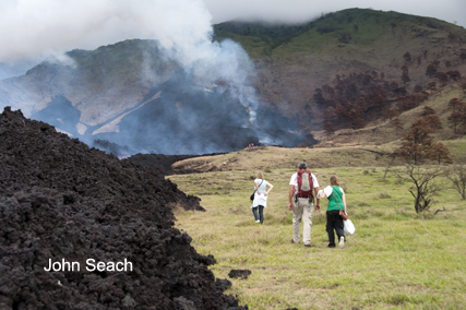
Pacaya eruption 2010
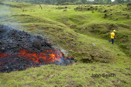
Pacaya lava flow front 2010
Lava flow extended 5 km down the southern flank in 2010.
A caldera forming eruption at Pacaya occurred 23,000 years ago. The volcanic complex contains three old summits: Cerro Chino (2260 m), Cerro Chiquito (2460 m) and Cerro Grande (2560 m). Two lavas (basaltic andesite and dacite), coexist at Cerro Chiquito dome.
Between 1961 and 2000 Strombolian activity persisted at Pacaya volcano, with two to three paroxysmal eruptions each year.
2013 Eruptions
Strombolian eruptions were observed at MacKenny crater in April 2013. This was the first recorded activity at Pacaya volcano since 2010. Tourists were advised to avoid MacKenny crater.
2010 Eruptions
Pacaya volcano, Guatemala erupted on 28th May 2010. Guatemala's President declared a state of "calamity" in two provinces and opened emergency shelters to accommodate over 1,700 residents who were evacuated. More than 65 people were injured, some people are missing, and hundreds of houses damaged by the eruption which sent stones and ash over a wide area. The international airport at Guatemala City remained closed for 20 hours. The runway was covered by 2.5 cm of volcanic ash. In February 2010 lava flows from Pacaya volcano descended 100-400 m down the E and NE flanks.
2008 Eruptions
Multiple lava flows, up to 300 m long, were visible at the volcano on 20th November 2008.
2005 Lava Flows
During January-March 2005 a new phase of activity developed at Pacaya, where the active cone emitted small amounts of lava. During March-April 2005 cracks opened on the MacKenney crater. In April 2005 an 800 m long lava flow effused from fissures on the cone's ENE side.
2000-2002 Lava Lake
From August 2000 to June 2001 a lava lake was present in the crater, and a glow and was often visible from Guatemala city.
2000 Paroxysmal Eruptions
Eruptive pattern changed in the year 2000. Paroxysmal eruptions occurred in January 2000, and 29th February 2000. Lava fountains began at Pacaya volcano at 1615 hr on 16th January 2000. The fountains reached a maximum height of 800 m. This was the largest eruptions at the volcano since the current eruptive cycle began in 1961. Fallout from the lava fountain produced nearly constant nuées ardentes and a lava flow that extended 600-700 m to the SW. Strombolian activity returned around 2030 hr. A second large eruption began at Pacaya volcano at 1815 on 29th February 2000. A lava fountain reach a height of 700 m above the summit.
1999 Eruptions and aircraft damage
On 21st May 1999 at least two commercial aircraft flew into ash clouds from Pacaya volcano near Guatemala city. Both aircraft were seriously damaged, but managed to land safely. One aircraft required engines to be replaced, at a cost of $2 million each.
1989 Eruptions
Explosive eruptions occurred at Pacaya volcano between 7-10 March 1989. Ashfall was reported on the south coast of Guatemala 50 km from the volcano. On the afternoon of 7th March an incandescent column of tephra rose 2000 m above the crater. Blocks were ejected 3000 m high. Ash fell at Cerro Grande, El Chipilinar, San Carlos, and Santa Elena Barillas, 7 km NE of the crater. Bombs and blocks up to 1.5 m in diameter fell in the La Meseta area 1.5 km north of the vent. On 8th March strong eruptions produced a 3000 m high plume. On 9th March ashfall occurred on the Guatemala-El Salvador border, 80 km from Pacaya volcano.
1988 Eruptions
Strombolian eruptions and lava flows occurred at Pacaya volcano in 1988. Explosions increased from a few hundred per day in early June to about 2,000 per day in mid-June, and reached a maximum of 3,300 on 5th October.
1987 Eruptions and Injuries
At the end of January 1987 eruptions at Pacaya volcano destroyed 63 homes and caused the evacuation of 3000 people. On 21st January at 1520 hr eruptions of Pacaya volcano injured 12 people at Calderas 3 km north of the volcano, when 25 cm blocks landed in the town. Ash fell at Chiquimula, 180 km ENE of Pacaya. The eruptions formed a new 160 m diameter crater within MacKenney Cone. On 25th January another explosion occurred at Pacaya volcano. An eruption column reached 8 km high. Houses in El Caracol (3 km SW), El Patrocinio (3.5 km W), and Los Pocitos (6 km SSE) were hit by 25 cm blocks. On person was admitted to hospital and many livestock were killed. A strong explosopn occurred on 14th June 1987. A column of ash, cinders, and lapilli were ejected 500 m above the summit. Cinder fell 100 km south of Pacaya, and the town of El Caracol (3 km SW) was evacuated.
1986 Eruptions
On 19th January a small lava dome had formed at the western base of MacKenney Crater.
1985 Eruptions
On 10th February a lava flow was observed moving NNE of MacKenney Crater. At the end of February, two vents were active inside the crater. Small strombolian explosions were observed at Pacaya volcano on 24th April, ejecting lava 20 m high about every 7 minutes. An active lava flow on the western flank of Pacaya volcano was observed by farmers, but not visited by scientists.
1984 Eruptions
Strong explosions were hear by residents near Pacaya volcano on 15th May 1984. The explosions destroyed half the active cone. Strombolian eruptions were occurring on 5th August.
1983 Eruptions
Strombolian explosions began at MacKenney Crater, Pacaya volcano in March 1983. On 17th July activity was seen and heard from nearby towns. On 16th November the active cone on the southern edge of MacKenney Crater, had grown to over 100 m high. Aa lava flowed from below the base of the active cone, and traveled down the north-west flank.
1982 Eruptions
Observations at Pacaya volcano on 12th February 1982 showed lava flowing several kilometers down the SSW flank, originating from a hornito at 2,100 m altitude on the SW flank. Lava continued to flow from the hornito as of 4th March 1982.
1981 Eruptions
Pacaya volcano showed Strombolian activity on 14th February 1981, for the first time since 1975. Explosions reached a height of 200 m above the crater at an interval of 10 seconds to 1 minute. The northern half of the crater floor was filled with pahoehoe lava. Eruptions rached a peak on 18th February at 1730 hr when lava overflowed the north rim of the crater and traveled down Pacaya's north flank. By 5th March the lava lake inside MacKenney Crater was at a higher level. Three vents in MacKenney Crater were aligned in a north-south direction.
1980 eruptions
A small cincer cone formed inside MacKenney Crater at the end of 1987.
1977 Eruptions
Ash emissions occurred from MacKenney Crater on 19, 20 and 27 August 1977. A strong smell of sulphur was reported at the volcano.
1976 Eruptions
Ash eruptions occurred at Pacaya volcano one day before an earthquake hit the area. The 4th February earthquake was immediately followed by black steam emission from MacKenney Crate.
1975 Eruption
A lava flow occurred at Pacaya in September 1975.
1973 Eruptions
Renewed ash eruptions occurred at Pacaya volcano on 13th January 1973. Lava flowed from a flank on the SW flank of the volcano.
1972 Eruptions
A lava flow began on 2nd February from Cerro Chino cone. The lava extended 1.5 km in 2 days in a westerly direction. Ash emissions accompanied the lava flow. New ash emissions occurred from MacKenney Cone about 15th October 1972, accompanied by enlargement of the crater.
1970 Eruptions
Strong eruptions occurred on 8th January 1970.
1969 Eruptions
Eruptions occurred at Pacaya in December 1969 with scoria emission from MacKenney Cone.
1775 Eruptions
Eruption of Pacaya volcano in 1775 produced tephra which reached Antigua 35 km NW. A lava flow extended 6 km SW from a vent on Cerro Chino cone.
Further reading
Rose, W.I., Palma, J.L., Wolf, R.E. and Gomez, R.M., 2013. A 50 yr eruption of a basaltic composite cone: Pacaya, Guatemala. Geol Soc Am Spec Pap, 498, pp.1-21.
Gomez, R.O.M., Rose, W.I., Palma, J.L. and Escobar-Wolf, R., 2012. Notes on a Map of the 1961-2010 Eruptions of Volcán de Pacaya, Guatemala. The Geological Society of America, Digital Map and Chart Series, 10(10).
Pacaya Volcano Eruptions
2013, 1961-2010, 1885, 1846, 1830?, 1805, 1775, 1760?, 1717?, 1699, 1693, 1690, 1687,1678, 1677?, 1674, 1671, 1668-69, 1664, 1655, 1651, 1623?, 1565.