Volcano Live
volcanolive.com
Fuego Volcano | John Seach

(Volcano of fire)
Guatemala
14.47 N, 90.88 W
summit elevation 3763 m
stratovolcano
Fuego is one of the most active volcanoes in the Americas, it has erupted repeatedly since 1524. It is located close to the city of Antigua Guatemala.
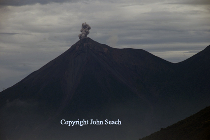
Fuego Volcano, Guatemala - John Seach
Eruptions have produced ashfall, pyroclastic flows and lava flows. The crater of Fuego, has changed its appearance many times, since the eruption of 1932.
Historic eruptions at Fuego volcano have been mostly basaltic in composition, but have become more mafic with time. This is proposed to be due to changing conditions of the parental magma chamber.
Volcanic
Hazards at Fuego Volcano
Lava flows. Pyroclastic flows. Lahars, ejection of blocks and bombs. Fall
of cinders, and ash. An
eruption of this volcano could affect 100,000 people who are in
the danger zone
2018-2019 Eruptions
Explosive activity, lava flows and lahars occurred at Fuego volcano between July 2018 and March 2019.
2013 Eruptions
A lava flow remained active at Fuego volcano in January 2013.
2012 Activity
Eruptions of Fuego volcano in Guatemala forced the evacuation of
33,000 people on 13th September 2012. The eruptions produced ash
emissions which were visible in the capital Guatemala City, 75 km
away. Pyroclastic flows travelled down the slopes of the volcano and
heavy ashfall was reported in nearby villages. Fuego volcano is
located 18 km SW of the city of Antigua. On the day of the eruption
a magnitude 4.2 earthquake hit 47 km south of the volcano. The
explosive phase of the eruption was preceded by emission of a 100 m
long lava flow down the flank.
1974 Eruptions
The 1974 eruption was the largest since 1932. Magma was inferred to
have risen into a dike-like conduit from a deeper magma body as a
result of tidal influences. The eruption began on 10th October with
ash eruptions and from a central crater. On 14th October ash clouds
rose to 11 km above the summit. Nuees ardentes descending the
Quebranda San Jose were visible from Finca Capetillo in Alotenango,
8 km ENE of the crater. Pyroclastic flows with velocities of 75 km
per hour reached 7 km from the crater.
Further reading
Waite, G.P., Nadeau, P.A. and Lyons, J.J., 2013. Variability in eruption style and associated very long period events at Fuego volcano, Guatemala. Journal of Geophysical Research: Solid Earth, 118(4), pp.1526-1533.
Vallance, J.W., Schilling, S.P., Matías, O., Rose, W.I. and Howell, M.M., 2001. Volcano hazards at Fuego and Acatenango, Guatemala. US Geological Survey Open-File Report, pp.01-431.
Martin, D.P. and Rose Jr, W.I., 1981. Behavioral patterns of Fuego volcano, Guatemala. Journal of Volcanology and Geothermal Research, 10(1-3), pp.67-81.
Fuego Volcano Eruptions
2002-2022, 2000, 1999, 1987, 1977-79, 1977, 1975, 1974, 1973, 1971, 1967, 1966, 1963, 1962, 1957, 1955, 1953, 1949, 1947, 1944, 1932, 1896, 1880, 1867?, 1861?, 1860, 1857, 1857, 1856, 1855, 1852?, 1850?, 1829, 1826, 1799, 1773?, 1765?, 1751?, 1737, 1732, 1730, 1717, 1710, 1709?, 1706, 1705, 1702, 1699, 1689?, 1686, 1685, 1679?, 1629-32, 1623, 1620, 1617, 1614, 1587, 1586, 1585, 1581-82, 1577?, 1576?, 1575?, 1571?, 1565?, 1559?, 1557?, 1551-52, 1542, 1541, 1531, 1526?, 1524